Sierra de Las Villuercas
Travellers
Sierra de Las Villuercas
Location and access
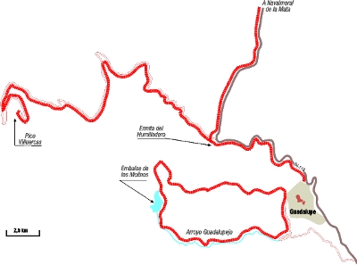

This route is in the mountainous massif of the Sierra de Las Villuercas, in the southeast of the province of Cáceres. The suggested route starts in the town of Guadalupe, which can be reached, from the north, from the A-5 (Navalmoral de la Mata) by the EX-118; from the south, from the N-430 by the EX-116 and the EX-102; from the east, from the A-5 (Miajadas); and, from the west, from Talavera de la Reina.
Description of the route
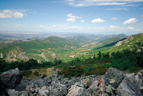
The route is about 54 km long, out and back, along a mix of roads and forest trails, from the town of Guadalupe to the end of the suggested route. It’s designed to be done by car in one day, stopping and taking short walks at the most interesting observation points. The route goes through varied habitats. At first it takes you towards the sources of the Rivers Guadalupejo and Ibor, between thick of groves of alder, ash, hazel and black poplar trees, then it goes up the mountain of Pico Villuercas, the highest point in the region at 1601 m.
The route starts in the town of Guadalupe, taking the small road that leads towards the viaduct of the abandoned railway line. Turn right at point (X:0299392, Y: 4368912), which coincides with a hairpin bend. From here the route takes you along a dirt track up the River Guadalupejo, a protected natural area that has been declared an Ecological Corridor. As you go along you will discover a very well conserved riverine grove which is good for woodpeckers: Great Spotted, Green and Lesser Spotted. It’s also possible to see Dipper here, flying rapidly over the currents, hopping over the stones or diving in the clean, transparent water that is so essential to its survival. It has a small population in these mountain ranges. As well as the natural and scenic values of the area you can also enjoy the presence of flourmills, and blacksmiths, associated with the prosperity of Guadalupe and its monastery, declared a Historical-Artistic Ensemble and a World Heritage Site, respectively. The route takes you to Los Molinos Reservoir, from where there is a magnificent view of the area known as Los Hoyicios, the source of the River Guadalupejo. Griffon Vulture, Egyptian Vulture and Peregrine Falcon nest in the quartzite crags of this spot. Continue along the track and turn right at point (X:0296656, Y: 4370768). From here you go upwards, skirting the mountain range, to admire one of the route’s most spectacular views: a mosaic of leafy Pyrenean oak, chestnut, black pine and gall oak groves and riverbank groves of alder, ash and poplar trees. The scenery is even more spectacular in autumn, when the deciduous trees turn golden. In spring and summer it’s possible to see European Honey Buzzard, which has a small breeding population in this area, the most southern in all of Spain. Continue along the track until you reach Guadalupe.
From here you should take the EX-118 towards Navalmoral de la Mata, then turn left at point (X:0297920, Y: 4371232) and take the road known as “la Carrera del Caballo”. This beautiful route runs next to the River Ibor along the Camino Real, a centuries-old pilgrimage road from Madrid to Guadalupe. The nearby Humilladero is worth visiting, a Mudejar style chapel where pilgrims knelt down on seeing the Monastery of Santa María de Guadalupe for the first time. We would recommend you carry on by car, parking next to the sawmill located at point (X:02979900, Y: 4372083), to then continue on foot along the bank of the River Ibor, where it’s possible to see – or hear – the Western Bonelli's Warbler, restricted to the mountain tops of the Sistema Central, Villuercas and Sierra de Tentudía in Extremadura. You can also see other species of birds typical of deciduous woods and groves: Golden Oriole, Cirl Bunting, Nightingale, Eurasian Jay, Long-tailed Tit, etc. With a bit of luck you will also see some indigenous species such as the Iberian Frog, Schreiber’s Green Lizard and Roe Deer, which will bark at you from the thickness of the chestnut groves.
Go back to your car when you reach the point where the path starts veering away from the river. From here return to the turning off point, then take the narrow road that leads up to a military base (now disused) and the highest point in the region: Pico Villuercas (1.601 m). As you go upwards you will see an obvious change in the vegetation, with the forest masses of chestnut, pine, Pyrenean oak, gall oak and whitebeam being progressively substituted by the junipers, brooms and heathers of the mountains, where the conditions are more hostile towards vegetation. The geological beauty of the scenery and its extraordinary relief is equally striking; called Appalachian relief, it is a peculiar succession of parallel valleys and mountain ranges, with many folds, faults and residual rocky areas. It is a perfect nesting habitat for lots of species: Griffon Vulture, Bonelli’s Eagle, Golden Eagle, Peregrine Falcon, Black Stork, Egyptian Vulture, Eagle Owl, etc.
As a curious aside it’s worth mentioning that the road up to the summit forms the dividing line of waters between the basins of the Tajo and Guadiana in such a way that the currents that flow on the left belong to the Guadiana (Rivers Guadalupejo, Ruecas, Gargáligas, etc.) and those on the right to the Tajo (Rivers Viejas, Ibor, Almonte, etc.).
Park your car on the left at point (X:0295440, Y: 4371720) to visit “Pozo de la Nieve”. This huge well, dug out of the rock, was filled with ice during winter in order to conserve the food and medicines of the Monastery and town of Guadalupe. From here you can see the vast landscapes of the valley of the River Guadalupejo and the low mountain range of Rañas de Cañamero.
Once you reach the summit it isn’t difficult to see characteristic species of mountain scrubland and rocky outcrops, including: Black Wheatear, Black Redstart, Dunnock, Alpine Accentor, Blue Rock Thrush and Rufous-tailed Rock Thrush, a rare breeding summer species that only nests in these mountain tops in Villuercas. You can also hear the shrill carrousels of the Alpine Swifts, a species that has important breeding areas in these mountain ranges, and the jubilant calls of the flocks of Red-billed Chough, a bird which has an irregular and localized distribution in Extremadura.
Ornithological interests
Due to the diversity of the habitats this route has many and varied ornithological interests. The summer visitors that breed here stand out, such as the European Honey Buzzard, Black Stork, Booted Eagle, Short-toed Eagle, Blue Rock Thrush, Alpine Swift and Egyptian Vulture.
The deciduous forest masses are the perfect habitat for nocturnal birds such as the Tawny Owl and there are isolated groups of Coal Tit in the pine groves. Western Bonelli’s Warbler and Lesser Spotted Woodpecker are common in the best conserved mountain forests. Peregrine Falcon, Golden Eagle, Bonelli’s Eagle, Eagle Owl and Griffon Vulture nest in the crags and rocky outcrops, among other species. Numerous species, such as the Black Wheatear, Black Redstart, Dunnock, Alpine Accentor, Blue Rock Thrush and Rufous-tailed Rock Thrush, can be found in the summits, between the rocks and the creeping bushes. The Spanish Imperial Eagle, which still doesn’t breed regularly in this region, shares the habitat with another large scavenger, the Eurasian Black Vulture, which started to nest in these mountain ranges just over a decade ago, in what appears to be an expansion from the colonies of Monfragüe. Pairs now nest in the most northern enclaves of the region, giving almost spatial continuity to the colonies of Monfragüe.
Best time to visit
It can be done at any time of the year. Spring is the most productive season, with good daytime temperatures and the return of the summer birds: Black Stork, Egyptian Vulture, Booted Eagle, Short-toed Eagle, European Honey Buzzard, etc. Spring is also the breeding season and, as a general recommendation for all the routes, you must not stray from the established route to avoid disturbing the birds during this sensitive period. Although part of the route goes through a mountain area it is very hot in summer, so make sure you drink plenty of fluids and protect yourself properly from the sun, avoiding the middle hours of the day, which are also less favourable for watching the birds. In autumn the colour of the deciduous trees, with their golden and yellow hues, marks this region culturally and scenically.
Other environmental and cultural interest
The Villuercas mountains are scenically outstanding because of their formation, a succession of valleys and mountain ridges in parallel, known as Appalachian relief. Both within the central zone as well as the edges one can find a great diversity of residual reliefs, folds, fossils, old quarries and deposits.
The area is important in terms of endemism and botanical interest, with numerous species of woodland orchid, relict trees such as the laurel (Prunus lusitanica ssp. lusitanica), a survivor of the temperate periods of the Tertiary. There is a high diversity of butterflies and dragonflies, indicators of the quality and diversity of the environment in this district.
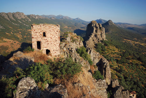
Without doubt, Guadalupe with its monastery, declared a World Heritage Site by UNESCO in 1993, and surrounding historic buildings, stands out amongst the towns and villages of the district. On the summits and strategic ridges, there are many pre-Roman settlements and castles, which formed a defensive line along the Tajo valley during the re-conquest.
The mountains conserve one of the most important collections of cave paintings in Extremadura, with more than 90 known sites where rock paintings can be found in sheltered overhangs, small caves and even exposed rocks. In Cañamero the Cueva Chiquita or Álvarez (Álvarez or Chiquita cave) is easy to visit. Some of the small caves around Berzocana are sign-posted and have information boards in place.